
Google Earth is an incredible application that allows you to explore the whole planet without leaving your seat. Featuring satellite photography, it has been one of the best, most favorite applications ever made. However, not many people know Google Earth alternatives that offer similar features.
If you want to see earth in a different way, there are some other services to take into consideration. We have compiled the most recommended alternatives to Google Earth so you can check on strange places from anywhere. Click on the link to visit the sites!
Table of Contents
12 Recommended Google Earth Alternatives
Google Earth is undoubtedly loaded with features to view a virtual map using satellite images. Most Google Earth alternatives offer similar features and additional features to explore geographical content in excellent quality. Here’s a closer look at the alternatives:
1. Google Maps

Google Maps is widely known for its ability for navigation. However, only few people know it can show satellite view photographs just like Google Earth. It allows you to visit any place, especially streets and navigate virtually. It works well to help you get to know places before visiting.
How to use satellite feature from Google Maps is quite simple. Choose Satellite from map type and the layer turns into satellite images. It also has Explore feature that allows you to visit popular places, mainly tourist destination so you know better about the place.
There are many other features to enjoy in Google Maps, such as search nearby places and location sharing. It also has the ability to show light traffic in the area, allowing you to arrive faster without delays.
2. OpenStreetMap

OpenStreetMap is pretty similar to Google Maps that focuses on navigation and direction. Using this app, you can find places from the search bar and get directions. Thanks to a world map that is free to access. On top of that, it is open to collaboration with any users.
This program has a number of features, such as trusted data sources from Landsat 7 satellite imagery, TIGER data, PGS, and Ordinance Survey OpenData. Being a collaborative project, it enables you to create editable app and use geographical data from anwhere.
OpenStreetMap works in a rather different way from Google Earth. However, it can be a great tool to travel the world and visit different places on earth. Thanks to a vast number of collaborators that makes it more advanced.
3. Google Street View
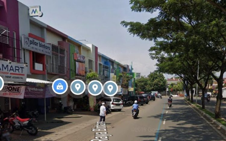
Street View is a Google Earth alternative that offers 360 degree panoramic images. It enables you to virtually explore new places in the world without having to leave your seat. Unlike Google Earth that provides images from bird’s eye view, Street View offers street-level panoramas.
This great tool allows you to view parts of cities, explore surroundings, and get lost virtually. You can also navigate through images and feel like being a part of the place. With worldwide support, Google Street View takes your virtual exploration to another level.
If you wonder where the photos come from, it has two main sources, Google and contributors. Google uses a special vehicle to track streets in many cities, giving you easier access to the places. Content is also sourced from contributors that usually comes with account name and a profile photo.
4. Global Mapper

Are you currently using Google Earth Pro and need a good alternative? Global Mapper could be the best bet. This Google Earth Pro alternative is a GIS software that offers a comprehensive spatial data processing tools for novice and geospatial professionals.
It comes with an extensive range of features from access to online data to rendering features. It has terrain analysis that can be used for model elevation data processing. It also supports a variety of 3D formats such Wavefront. Collada, and many more.
On top of that, Global Mapper features GPS tracking. You will need to get a compatible GPS receiver and this software will display the location on the map. It also features extension plugin supports to add more functionality such as enhanced visualization to the new toolbar.
5. QGIS
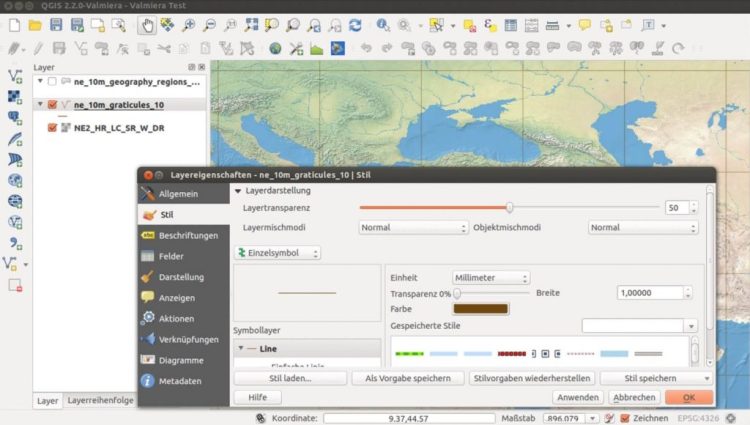
Similar to Google Earth, QGIS is a free and open-source GIS program with a wide range of capabilities. It allows you to do a lot of things from creating geospatial information to publishing it from Windows, Mac, or Linux devices. Thanks to core features and plugins that make it happens.
This geographic information system has many features. It supports an extensive range of data formats through the View Data feature. It enables you to view vector and raster data combination in different formats such as MS SQL Spatial, Oracle Spatial, GeoTIFF, and many more.
In this app, you can also enjoy the Python Console for scripting. In order to interact with the QGIS environment, it comes with QGIS interface that provides access to the menus, toolbars, and map canvas. And, it enables you to publish data on the internet.
6. NASA WorldWind

Another cool alternative to Google Earth is WorldWind. This open-source virtual globe application lets you have a distinct experience with geospatial data. It may work differently from Google Earth but if you are a developer or student who wants to build a planetary model, it has got you covered.
It provides you with a high-performance 3D model of the planet with an extensive component of geographical layers and geometric objects. NASA has handled the geographic data such as terrain with various elevation models so you can focus on building any application you want to create.
As an open-source program, it allows you to create interactive visualization of 3D map, globe, and geographical information. You can also express and analyze spatial data to build powerful applications such as satellite tracking system.
7. Marble

Explore the world virtually with Marble. This Google Earth alternative is a virtual globe with the ability to measure distance and pan around new places. With a user-friendly interface, this versatile app is completely easy to use. Not to mention it comes with a complete set of features.
Having Marble on your desktop PC or laptop allows you to enjoy a world atlas for different purposes. It is packed with basic controls for scrolling and zooming so you can easily navigate to desired area. This program also shows images from Blue Marble service.
If you are not enough with earth, Marble offers a spectacular feature to enjoy. Explore the moon and other planets with available maps so you can get an unforgettable virtual experience. Plus, it enables you to update information about weather from various sources.
8. Zoom Earth

Zoom Earth is one of cool Google Earth alternatives with similar functions to Google Earth. Using this app, you can view satellite photographs and search for places around the globe. Thanks to graphical capabilities that allows you to view high quality maps of roads and cities.
Downloading Zoom Earth on your device offers a lot of advantages. Not only can you get a complete virtual map, but you can also manage information like favorite routes, favorite cities, and much more. It also has the ability to share locations to friends or family.
There are many other features to find, such as area measurement and distance measurement. You can also easily search for places using the search feature. Plus, this live satellite app enables you to view attractive wind animation and track natural events.
9. 2GIS

2GIS is a geographic information system application to explore cities and new places virtually like Google Earth offers. While Google Earth provides satellite images, 2GIS shows a 3D city map with beautiful details, including fences and driveways.
In this app, you can easily find routes to public transportation. This feature is similar to Google Maps, only better. It has the ability to show the exact location of bus stops along with the routes. It also enables you to see all the transportation network in the city.
Featuring a user-friendly search engine, it has everything you need to know about the city including companies. You will find out small enterprises to big companies including their phone number, working hours, and address.
10. MapQuest

MapQuest is another Google Earth alternative to find locations worldwide. Much like Google Maps, it shows maps and provides you with easy navigation to any destinations. Featuring basic controls like zoom in and zoom out, it comes in handy to view maps.
In addition to vector graphic, MapQuest supports satellite images. Simply click the Satellite option from the control bar, zoom in, and pan around to see everything from bird’s eye view. It is also equipped with arrow buttons for easier panning, although you can do it directly from the cursor.
Checking on traffic is made simple with MapQuest. From the traffic button on the control bar, you can choose categories like traffic slowdowns, traffic incidents, and even traffic webcams to monitor everything on the road.
11. WhirlyGlobe

WhirlyGlobe is a useful map app that comes with a variety of functions. It delivers 2D flat map and 3D interactive globe with beautiful graphics. There are so many features to find in this app, such as animated images, labels, and annotations.
This application also comes with markers that enable you to put mark on both 2D and 3Dmaps. Other features to enjoy include shaders, WMS, and GeoJSON.
Thanks to the user-friendly interface that makes WhirlyGlobe easy to use. It supports many cities worldwide so you can search for any places you wish to explore. With an open-source nature, it allows you to make changes and develop the app.
12. Here WeGo

Getting around places is getting a lot easier with Here WeGo. This app provides you with maps of cities around the globe so you can explore virtually. It also functions as a navigation app that helps you get into places without getting lost.
Here WeGo allows you to choose different map views, from satellite to terrain. If you want to get the same experience as Google Earth, simply choose satellite map type. You can also choose transit, traffic, and terrain options if you wish.
Traveling the world virtually is easier with Google Earth alternatives. Featuring similar functions, you can view world maps and city maps either from street level or bird’s eye view. It is good to know that some apps come with better functions such as navigation and app development.